Measure Piles Without Climbing Them
Volumetric Analysis and Measurement in Florida and Alabama
When you're managing stockpiles of aggregate, soil, or other bulk materials in Jacksonville and surrounding areas, knowing how much material is on hand affects ordering, billing, and site planning. Walking a pile with a tape measure doesn't give you reliable volume, and manual data collection takes time your crew could spend on other tasks. Aerial Metrology & Inspection uses drone-based data collection and processing software to calculate stockpile volumes with repeatable accuracy, so you know exactly what you have without sending anyone up a slope or into unstable material.
This service is used in mining, aggregates, construction sites, and material yards where volume tracking matters for inventory, invoicing, or loss prevention. We capture the pile from above, process the data into a 3D surface model, and calculate volume against a defined base elevation. The result is a report that shows cubic yards or tons, depending on material density, along with visual documentation of pile shape and location.
If your site in Jacksonville, surrounding Florida communities, or select areas in Alabama depends on accurate material counts and you want data-driven reporting instead of rough estimates, reach out to discuss your measurement needs.
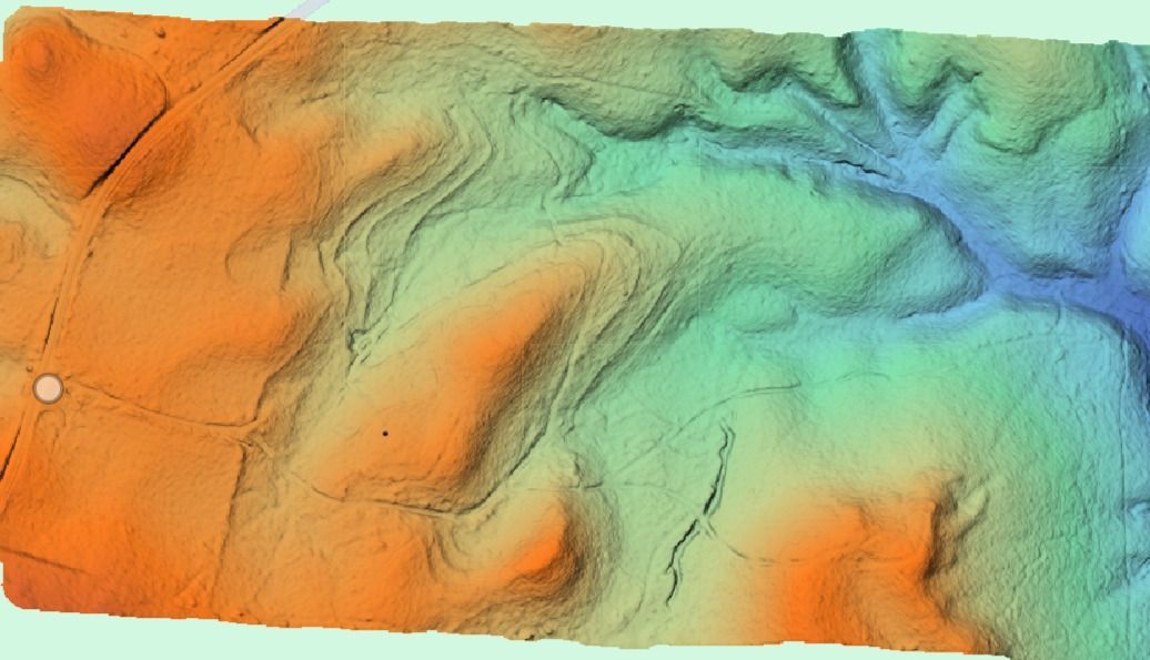
How Volume Measurement Actually Works
Volume measurement starts with a flight over your stockpile using a drone equipped with a high-resolution camera or LiDAR sensor. We process the images or point cloud data into a 3D model that represents the pile's surface. Then we define a base plane—either the ground level or a custom reference elevation—and calculate the volume of material above that plane. For sites in Jacksonville and surrounding areas, we can measure single piles or track multiple stockpiles across a large yard in a single visit.
Once the analysis is complete, you receive a report with volume totals, cut-and-fill comparisons if tracking changes over time, and a visual map showing pile locations and dimensions. Repeatable measurement tracking reduces material loss by making discrepancies visible and gives you a defensible record for billing or inventory audits.
Reports can be delivered as PDFs, CAD files, or spreadsheets depending on how your team tracks data. This service does not include material sampling or density testing—volume is calculated from shape and dimensions, and you apply density factors based on your material type.
Questions About Accuracy and Timing
Most clients want to know how accurate the numbers are and how often they should schedule measurements.
What if I need a licensed survey?
We are fully licensed to provide all survey requirements in Florida. Florida Business License Number: LB8710.
If you're managing stockpiles or site materials in Jacksonville and surrounding areas and need repeatable, defensible volume data, Aerial Metrology & Inspection can deliver reports that support inventory tracking, billing, and material management. Contact us to schedule a site visit and discuss your measurement timeline.
